

A massive cloud of dust from the Sahara Desert blanketed most of the Caribbean on Monday in the biggest event of its kind this year as it heads toward the United States. The cloud extended some 3,200 km. from Jamaica to well past Barbados in the eastern Caribbean, and some 750 1,200 km. from the Turks and Caicos Islands in the northern Caribbean down south to Trinidad and Tobago.
The hazy skies unleashed sneezes, coughs and watery eyes across the Caribbean, with local forecasters warning that those with allergies, asthma and other conditions should remain indoors or wear face masks if outdoors.
The dust concentration was high, at .55 aerosol optical depth, the highest amount so far this year, said Yidiana Zayas, a forecaster with the National Weather Service in San Juan, Puerto Rico.
The aerosol optical depth measures how much direct sunlight is prevented from reaching the ground by particles, according to the U.S. National Oceanic and Atmospheric Administration.
The plume is expected to hit Florida, Louisiana, Alabama and Mississippi late this week and into the weekend, DaSilva said.
However, plumes usually lose most of their concentration in the eastern Caribbean, he noted.
“Those islands tend to see more of an impact, more of a concentration where it can actually block out the sun a little bit at times,” he said.
The dry and dusty air known as the Saharan Air Layer forms over the Sahara Desert in Africa and moves west across the Atlantic Ocean starting around April until about October, according to NOAA. It also prevents tropical waves from forming during the Atlantic hurricane season, which runs June 1 to Nov. 30.
June and July usually have the highest dust concentration on average, with plumes traveling anywhere from 5,000 feet to 20,000 feet above the ground, DaSilva said.
In June 2020, a record-breaking cloud of Sahara dust smothered the Caribbean. The size and concentration of the plume hadn’t been seen in half a century, prompting forecasters to nickname it the “Godzilla dust cloud.”
Sicily
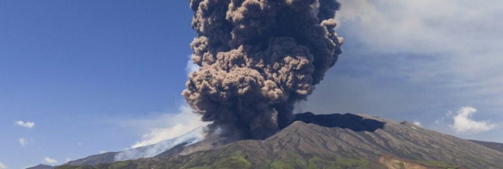
Meanwhile, Sicily’s Mount Etna put on a fiery show Monday, sending a cloud of smoke and ash several kilometers into the air, but officials said the activity posed no danger to the population.
The level of alert due to the volcanic activity was raised at the Catania airport, but no immediate interruptions were reported. An official update declared the ash cloud emission had ended by the afternoon.
Italy’s INGV National Institute of Geophysics and Volcanology said the spectacle on Europe’s most active volcano was caused when part of the southeast crater collapsed, resulting in hot lava flows. It was the 14th eruptive phase in recent months.
The area of danger was confined to the summit of Etna, which was closed to tourists as a precaution, according to Stefano Branca, an INGV official in Catania.
Video showed tourists running along a path on the flank of the vast volcano with smoke billowing some distance in the background. Excursions are popular on Etna, which is some 3,300 meters high, with a surface area of some 1,200 sq. m.
If this article was shared with you by a friend or colleague, you may enjoy receiving your own copy of Travel Industry Today with the latest travel news and reviews each weekday morning. It’s absolutely free – just CLICK HERE.